Son of a Gloucester baker Charles Mason and dismissed Quaker Jeremiah Dixon born into a mining family in Bishop Auckland, County Durham were acknowledged scientists when they were commissioned to resolve a land dispute in the British Crown colony that was America in 1763.

The Calvert family of Maryland and the Penns of Pennsylvania had been locked in an eighty-year often bloody dispute over the boundary between the two colonies they had been awarded under royal seal of approval. This was a battle for high stakes involving roughly 4,000 square miles of territory with complete confusion as to who taxes should be paid to. Thus all out warfare along the border had become a regular occurrence.
Existing maps were outdated maps, therefore meant fresh set of measurements were required, but as colonial surveyors had proven to be inaccurate, the families hired Mason and Dixon, well known in England as master surveyors and astronomers.
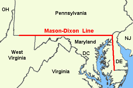
Thus the Mason-Dixon Line was mapped and drawn in two parts. An 83-mile (133.5 kilometres) north-south divide stretch between Maryland and Delaware and the better known 233-mile (375 kilometres) west to east dividing line between Pennsylvania and Maryland, drawn from slightly south of Philadelphia to what is now the state of West Virginia in the Appalachian region of the Southern United States.
Mason and Dixon brought with them some of the most advanced surveying equipment of the day, including tools by renowned instrument maker John Bird, who, like Dixon, originated from County Durham. The pair were originally brought together in 1761 to map the Transit of Venus simplifying calculation of the Earth's distance from the Sun.
The map they produced is considered to be one of the most important historical documents in America, attracting almost the same reverence as the Declaration of Independence. Its accuracy is so remarkable that it continues to astound people to the present day and most experts acknowledge it as the first geodetic survey in the New World. It took Mason and Dixon almost five years, struggling with their equipment across hundreds of miles of wilderness, to complete the survey.
They arrived in Philadelphia to begin work in November 1763. Empoying Bird's instruments to calculate their path by the stars faced by hostile Native Americans, mountains, dense forest, rivers and dangerous wild animals.
Limestone markers up to 5 feet (1.5 metres) tall – surprisingly quarried in England then transported to America - were placed at each mile interval and marked with a ‘P’ for Pennsylvania and ‘M’ for Maryland on each side. The average weight of each limestone marker was 500 pounds (226 kilograms). Then so-called Crown stones were positioned every five miles and engraved with the Penn family's coat of arms on one face and the Calvert family's on the other.

There were few roads if any and to navigate predominantly mature forest they had to cut a corridor some 30 feet wide. This required a small army of specialist labour:- woodsmen to fell the trees with axes, pack mule drivers to pull the trees to the side of the track, along with cows for milking, chain carriers, as well as instrument and tent bearers.
The Mason and Dixon Line Preservation Partnership’s Todd Babcock summed up the overall project’s accuracy in the context of modern technologies.
‘They thought at the end of the survey that the stones were accurate to within 50 feet of where they should be. But what we're finding is that some of them are as much as 900 feet off the intended line of latitude.
‘Using modern GPS equipment we found they progressively went to the south and then started to come back to the north. The reason for that is not because they were inaccurate or because the equipment was faulty. It was actually gravity.
‘Gravity had an impact on the plumb bob they were using. They had a 6 foot telescope and it used a plumb bob on a fine wire to set it to true zero so they could measure directly overhead. But gravity varied from location to location because of the influence of things like mountains.
‘We have found there was a direct correlation between the local variations in gravity and how far north or south of the line they were.
‘The distances between the stones are supposed to be a mile, but what we're finding is that they are anything up to 15feet longer than a mile in places.
"That said, the idea of trying to stay on a line of latitude for 230 miles through the wilderness with equipment that had never been used before is just incredible.’
However, the pair were to initially remain anonymous despite their achievement with the term ‘Mason-Dixon Line’ only to become more widely used when the Missouri Compromise was passed in 1820 which enabled slave-owning Missouri and free Maine to join the union.
While the line's longer term symbolism was only to become firmly established following the outbreak of the American Civil War in 1861, as the demarcation between the Northern freedom and Southern enslavement.
